You want a dog that can run ahead on trail without vanishing into a dead zone. That calm comes from choosing coverage that matches the terrain—not the sleekest city-escape demo.
This guide picks the best dog tracker for hiking by failure mode: where LTE freezes, when a Garmin-class off grid dog gps tracker earns the pack weight, and when a cellular collar is still enough for frontcountry days. The best dog tracker for hiking is the one that still works after the last cell tower disappears—not the one with the prettiest suburban app demo.
We cover trail dead zones, off-grid kits, LTE caveats, packing drills, and a simple buying verdict. For the broader tech map first, see our cellular vs off-grid vs Bluetooth buying guide; for brand shortlists after you pick a class, see best GPS dog trackers by category and the Fi vs Tractive vs Garmin comparison.
Why hiking breaks normal LTE collars
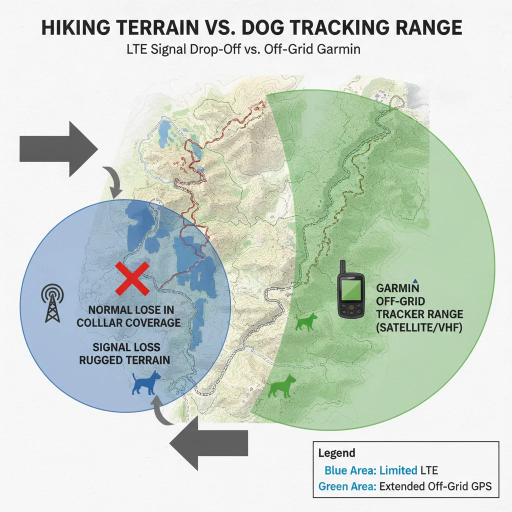
Most “best GPS” listicles assume a neighborhood chase: open gates, sidewalks, and phone maps that update every few seconds. Hiking breaks that story the moment the dog drops into a canyon, skirts a ridge, or leaves the trailhead parking lot’s strong bars.
A cellular collar needs towers. When coverage gaps, live track becomes a last-known pin plus hope. That is fine if you are two blocks from home. It is a different risk when you are four miles from the car with fading light.
LTE collars freeze to a last-known point in canyon and ridge dead zones; an off-grid dog gps tracker keeps the chase alive when towers do not. Treat that freeze as a design feature of the tech class—not a rare bug you will never meet.
Dead zones hide behind trailhead bars
Many trailheads sit near roads with solid LTE. The first mile feels safe. Then the corridor narrows, trees thicken, or the drainage drops below the ridge line. Your phone still shows a cached map. The collar stops refreshing.
Owners misread that early confidence. They tested the app in the lot, saw a clean track, and assumed the whole loop was covered. Coverage is not a yes/no stamp for a park name—it is a path-by-path reality.
- Strong bars at the lot ≠ continuous coverage on the ridge
- Switchbacks and drainages often kill live updates first
- Roaming plans do not invent towers where none exist
Live-track battery drain on long days
Even where towers exist, live tracking pulls harder than idle GPS logging. A six-hour hike with frequent “find my dog” refreshes shortens the day you thought the collar promised on the box.
Cold mornings make it worse. Batteries sag, screens stay on, and you burn reserve on the approach before the real off-leash section starts. Hikers who treat battery like water—measured and planned—lose fewer dogs to empty hardware.
Build a rule: if you need continuous live map for the whole day, pack a mid-hike charge plan or accept that the collar may drop into power-saving behavior exactly when you need it.
False confidence from suburban demos
Brand videos show green yards and city streets. Those demos prove the app UX, not wilderness reliability. A dog tracker no cell service scenario is the real product test for trail people.
If your weekly miles leave coverage, shopping Fi- or Tractive-first because friends love them for apartment escapes is the wrong starting point. Start with terrain. Then shortlist brands inside the tech that survives that terrain.
Best off-grid picks for wilderness
When the job is “dog ran over the ridge and towers are gone,” you want a radio/GPS kit built for chase—not a phone-first LTE collar. In practice that means Garmin Alpha/Astro-class systems and similar hunting/trail kits with a handheld that talks to the collar without cellular membership.
These are heavier, pricier up front, and less Instagram-friendly. They also answer the hiking question LTE cannot: can I still navigate toward the dog when my phone has no service?
| Use pattern | Primary pick class | Why | Watch-outs |
|---|---|---|---|
| Weekly no-cell ridgelines | Garmin-class handheld + collar | Works without LTE; chase workflow | Learning curve; kit cost |
| Mostly frontcountry parks | LTE collar + offline map habit | Phone UX; lower pack bulk | Dead-zone freeze risk |
| Mixed: city week, trail weekend | Off-grid primary or dual layer | Covers both failure modes | Weight and budget |
| Backup only | Bluetooth tag | Cheap second chance near people | Useless deep off-grid |
Garmin Alpha/Astro class, in plain terms
A garmin dog tracker hiking setup typically pairs a collar with a dedicated handheld. You see direction, distance, and track without relying on a cell network. That is the core transformation: you keep moving toward the dog instead of waiting for a tower to return.
Expect training time. Menus, map layers, and collar settings are closer to outdoor GPS culture than consumer pet apps. Budget an evening at home plus a short practice hike before trusting the system on a remote overnight.
Also expect weight. The handheld lives on a sternum strap or pack pocket, not in a jeans pocket like a phone. If you refuse that workflow, you are not buying an off-grid kit—you are hoping LTE will be enough.
Subscription math flips here too. Many LTE collars look cheaper on day one, then bill monthly. A dog gps no subscription off-grid kit shifts cost into hardware and maps. Over two or three hiking seasons, that often lands closer than sticker shock suggests—especially for multi-dog households that would otherwise buy multiple memberships.
Still, do not buy Garmin-class gear as a status object. If you will not train the UI and carry the handheld, the money is wasted. The product only works when the handler uses it under stress.
Setup before the trail
Do not first power on the kit at a remote trailhead. Charge both collar and handheld the night before. Confirm firmware, map region, and collar ID pairing while you still have Wi‑Fi for updates.
- Fit the collar so it cannot rotate or slip over the ears on brushy trails
- Set update rates you can sustain for the full day
- Mark the parking pin and a bail-out waypoint on your own navigation device
- Run a 10-minute hide-and-seek drill in a local park with known coverage gaps
That drill teaches the handler more than the dog. You learn how fast the bearing updates, how the screen behaves in sun glare, and whether your pack strap placement is stupid.
Train the dog–handler pair
Hardware cannot replace recall. Off-leash hiking still needs a dog that checks in and a human who can stop a chase early. Use the tracker as a recovery layer, not a permission slip for zero training.
Practice “come” with high-value rewards on short off-leash segments first. Then extend distance only when the dog reorients reliably. A tracker that points to a deer-chasing silhouette a mile away is still a long, stressful day.
- Whistle + reward pair before remote miles
- Practice collar on/off so the dog ignores the bulk
- Agree on a human protocol if signal freezes: stop, last bearing, sweep plan
When an LTE collar still makes sense
Not every hike is a wilderness epic. Frontcountry loops near towns, popular parks with roadside towers, and shoulder-season day hikes with mixed coverage can still suit Fi-, Tractive-, or other LTE-class collars—if you accept the freeze risk and plan for it.
Choose LTE when your primary risk is a roadside bolt or a busy trail network where phones are common and towers usually hold. Choose off-grid when dead zones are weekly life, not rare surprises.
Frontcountry trails and mixed coverage
If most of your miles stay within a few miles of pavement and you routinely have bars, a cellular collar can be the lighter primary. Keep offline maps on your phone. Know the last ridge where coverage historically drops.
On mixed routes, treat the LTE collar as “best effort live map” and carry a paper or offline plan for the known dead segment. Some hikers add a Bluetooth tag as a close-range backup at crowded trailheads—never as the wilderness primary.
Fi / Tractive caveats for hikers
These brands shine for suburban escape alerts, membership features, and phone UX. Hikers should still ask hard questions:
- Does your exact trail corridor keep LTE, or only the lot?
- What happens to battery under continuous live track in cold weather?
- Is travel/roaming relevant if you hike across borders?
- Will you actually keep the membership for three years?
If answers are fuzzy, do not buy on influencer trail photos alone. Re-read the tech decision in the buying guide, then return here for terrain-specific packing.
One more honesty check: international roaming and rural US coverage are not the same product story. A collar that shines on European travel networks can still go quiet in a US wilderness canyon. Match the network footprint to your actual trail map, not the marketing country count.
Packing and failure drills
Trail confidence comes from failure drills and spare power—not marketing range claims measured on open farmland. The kit that looks complete on the kitchen table still fails if the handheld is at 12% when the dog bolts at mile eight.
Spare charge plan
Pack power the way you pack water. For day hikes: full charge plus a small power bank that can top up the handheld or phone. For overnights: spare battery strategy per manufacturer guidance, and a rule that tracking hardware gets charged before camp lights.
- Night-before charge checklist on both collar and handheld/phone
- Mid-day top-up if live track has been heavy
- Cold-weather battery inside a jacket pocket when idle
Backup whistle and recall
When electronics glitch, sound still travels. Carry a whistle you have trained with. Keep a high-value reward accessible—not buried under the rain shell.
Also carry a simple visual signal plan with hiking partners: who sweeps left, who holds the last-known point, who returns to the trail junction. Panic burns time faster than dead batteries.
What to do when the map freezes
- Stop moving randomly. Note time, last good bearing, and terrain.
- Call/whistle on a schedule; listen between attempts.
- Sweep likely drainages and game trails from the last ping—not the opposite ridge first.
- If you carry dual tech (LTE + off-grid), switch roles deliberately instead of staring at a blank app.
- Set a turnaround time before dark that preserves a safe walk-out.
Write that drill on a small card the first season. Muscle memory beats optimism when adrenaline spikes.
After any real freeze event, debrief like a near-miss. What battery percent remained? Which bearing was last good? Did the collar rotate or snag? Adjust fit, power plan, and update rate before the next remote day. Hikers who iterate after scares get safer kits than hikers who only shop once.
Hiker buying verdict
Match the tool to the miles you actually hike, not the miles you aspire to post.
| Hiker profile | Primary recommendation | Secondary layer |
|---|---|---|
| Weekend frontcountry, usually has bars | LTE collar you will keep charging | Offline maps + whistle; optional Bluetooth backup |
| Regular no-cell wilderness days | Garmin-class off-grid kit | Phone offline maps for your navigation |
| Backcountry multi-day | Off-grid primary + strict power plan | Partner protocol and spare capacity |
| Hunting / long-range chase dogs | Purpose-built Garmin-class system | Training time before season opener |
Weekend frontcountry
Buy cellular if coverage is honestly good on your loops and you want phone alerts. Accept that one bad canyon can still freeze the map. Practice the freeze drill anyway.
Backcountry multi-day
Buy off-grid as primary. Membership LTE features will not invent towers on day three. Prioritize handheld fluency and collar fit that survives brush and weather.
Hunting dogs
Treat this as a specialist category. Hunting-oriented Garmin kits exist because the job is long-range chase, not sidewalk geofencing. Train before opening day; do not debut the UI on the first hunt.
Frequently Asked Questions
Will Fi or Tractive work on remote trails?
Only where LTE reaches. Deep canyons and backcountry often drop them—plan for that failure mode.
Is Garmin overkill for day hikes?
For well-covered frontcountry parks, maybe. For regular no-cell routes, it's usually the safer primary.
Do I still need a GPS watch or phone map?
Yes. Dog trackers locate the dog; they don't replace your own navigation.
What's the #1 hiking setup mistake?
Testing the tracker only at home Wi‑Fi/LTE and never practicing a dead-zone recovery drill.
Can Bluetooth tags help on trails?
Rarely beyond close range or crowded trailheads; don't rely on them off-grid.
Final recommendation
Shop terrain first. If your dog’s risk lives beyond cell service, an off-grid Garmin-class system is the honest best dog tracker for hiking primary—not a prettier LTE app. If your miles stay in covered frontcountry, a cellular collar can still win on weight and convenience, provided you respect dead-zone freezes.
Then run one failure drill, pack spare power, and keep your own navigation independent of the dog’s collar. Do that, and you become the hiker who still has a bearing when the trail goes quiet—not the owner staring at a last-known pin with no plan.
Related reading on our sister sites: Best Orthopedic Dog Bed for